Imaging Gabon South Basin – A Step Into The Unknown
Paris, France | Nov 16, 2016
CGG deploys a cutting-edge technology toolbox to tackle this complex frontier
Building an accurate and robust velocity model can be a complex task at the best of times. The largest seismic surveys push the boundaries of both hardware and software capacity and throughput. Furthermore, such large surveys can encompass a wide variety of geological features and water depths. Working in an underexplored area adds further difficulty, due to the lack of previous experience and absence of well data.
Many tools exist for velocity model building, each better at some tasks and less suited to others. Delivering the best overall velocity model relies on a successful combination of these tools, each being used to its strength on a different aspect of a project, in an iterative manner and guided by the geological and geographical variations.
Such were some of the challenges faced by CGG on its 25,000 km2 multi-client offshore survey in the South Gabon Basin. This survey was acquired between 2014 and 2015 using CGG’s BroadSeis™ solution with a 10-km long variable-depth streamer configuration. To put that areal size into perspective, the whole of Wales is approximately 20,000 km2. Considering the size and location of the Gabon survey it is easy to imagine the contrasting terrain contained within.
Due to the lack of pre-existing velocity data and limited wells in the area, an initial velocity model was built purely from Dix conversion of time-domain RMS velocity data. What little well data existed was used at each stage of the model-building process as a QC. Regional knowledge of the West African margin provided simple yet realistic anisotropy values that were used initially in a horizon-dependent fashion. The anisotropy values were updated and refined throughout the velocity model building process.
From this starting point, cascaded tomography was used for the first stage of velocity model building. The input seismic gathers were frequency-filtered into three bands: low (0-15 Hz); mid (15-30 Hz); high (>30 Hz). The low band targeted regional variations, the mid band added moderate velocity detail while the high band picked out high-resolution features in the sedimentary overburden.
The next tool used was multi-layer tomography which tackled near-surface velocity anomalies associated with complex seafloor topography features such as channels and canyons that can cause severe seismic distortions beneath them. It also targeted variations in the water layer velocity.
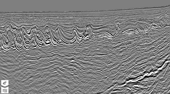
The geology of the South Gabon Basin is highly complex, featuring extensive faulting along with many salt and carbonate structures in both extensional and compressional domains. The geology can be summarized into three main types: the sedimentary overburden; the salt and carbonate zone; and the deep pre-salt region. Each type benefits from different velocity model building technologies.
At this stage, all the velocity updates had been in the post-salt sedimentary region. To move to the salt and carbonate zone, the data were migrated using both controlled beam migration and reverse time migration, with a constant velocity salt flood beneath a preliminary top salt horizon. These migrated volumes were used to perform a sophisticated interpretation of the salt features and related overhangs.
The project was now at a stage suitable for the use of full-waveform inversion. This provided highly-detailed updates everywhere reached by the diving waves recorded in the data, which in practice meant down to the top of the salt and carbonate features. This fully solved the velocity complexity related to the seafloor canyons, estimated earlier. Full-waveform inversion also identified features such as gas pockets, faster sedimentary layers and buried channels which were too small to be resolved by tomography.
Alongside the full-waveform inversion, targeted updates using structurally-constrained tomography were made to correct the velocity in mini-basins between high-velocity carbonate rafts. This also improved the imaging of the deeper pre-salt region beneath.
The final tool deployed was high-definition tomography. This was used to add structurally-conformable detail within the salt and carbonate zone, where the full-waveform inversion had struggled due to a lack of diving wave penetration. Here we see the strength of one tool being used to assist a weakness of another.
In this ongoing project with further velocity model building still to come, CGG has thus far deployed a selection of tomography technologies, including cascaded, multi-layer, structurally-constrained and high-definition varieties. Full-waveform inversion, salt interpretation and anisotropy updates have also been included. Combined together, these high-end technology solutions provide a highly-detailed velocity model encompassing a huge geographic area and complex geological variations.
For more in-depth coverage of this topic, don’t miss our technical paper “Velocity model building offshore Gabon - a vast step into the unknown” at 12pm on Wednesday. Alternatively, speak to CGG on booth E24 and check our booth theatre schedule.
