Encontrado: Imaging a New Exploration Frontier
Paris, France | Oct 18, 2016
Ultramodern images help to assess exploration blocks in Mexico’s Licensing Round
CGG has a wealth of advanced imaging experience and expertise in the Gulf of Mexico on both sides of the border. This track record ranges from the industry’s first wide-azimuth (WAZ) surveys and CGG’s four-year program with Pemex in the deep offshore Mexican Gulf, to its state-of-the-art StagSeis™, full-azimuth, long-offset broadband multi-client surveys conducted over the Garden Banks, Keathley Canyon, Walker Ridge and Green Canyon areas in the US. The deep knowledge of the regional geophysics and geology gained throughout these programs, combined with the continued development of leading processing technology, have brought significant improvements to final image quality to enable increased confidence in the development of prospects.
CGG is now bringing its years of experience in advanced imaging to the Mexican portion of the prolific Perdido fold belt. The aim is to apply the latest technology to resolve the large-scale, complex geological challenges and produce high-quality, intermediate products for the assessment of the blocks available in the upcoming licensing rounds. The Encontrado reprocessing project is a merge of nine existing surveys, acquired with different orientations, straddling the USA/Mexico border. The majority of the data is WAZ but the project also includes some narrow-azimuth surveys. This extensive volume of over 38,000 km2, of which 35,000 km2 is located in Mexican waters, covers some of the most prospective areas of the Gulf of Mexico, including the Great White and Trion discoveries.
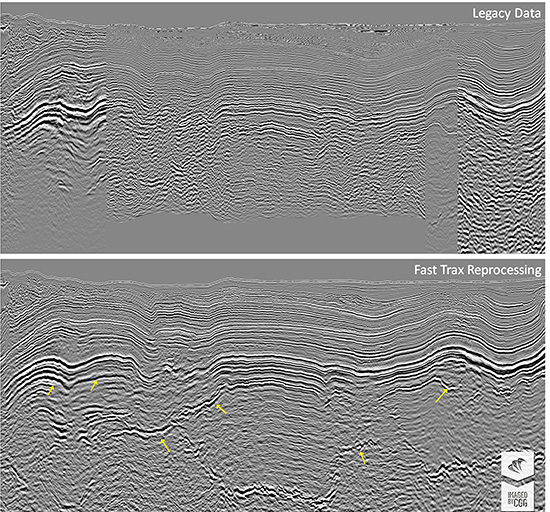
The goal is to turn the Mexican side of Perdido from a frontier area to a well-understood basin. Three major data volumes will be created: Fast Trax, for regional interpretation and the first correlation between structures in Mexico and the USA in advance of the next lease sale; Early Out, for updating the subsalt exploration portfolio; and Final PSDM for potential prospect evaluation. Despite the vast size of the project, the Fast Trax volume was completed in less than six months, to be ready well in advance of the bidding process, and is available for license now.
The key pre-processing step was 3D deghosting to extend the bandwidth and create a single continuous broadband volume. Deghosting delivers broader bandwidths with narrower wavelets and reduced sidelobes, for sharper, better-focused images. The deghosted data delineate the top of salt with a strong positive impedance peak, resulting in a less ambiguous salt interpretation.
Velocity model building for the Fast Trax data volume included several iterations of supra-salt tomography, incorporation of generalized salt geometry definition and velocity re-trending for the shale and sub-salt. The velocity model obtained correlates with regional geological features. The resulting Fast Trax data not only shows a seamless image between the USA and Mexico, with better continuity of the Perdido folds, but also considerable improvement to the imaging of the Mesozoic and basement, increasing the regional understanding.
Experience gained while processing the Fast Trax combined with advanced velocity modeling is being employed in order to obtain the best possible final image. Full Waveform Inversion (FWI) was applied over the entire 38,000 km2 survey. Such a regional-scale application of FWI maximizes the value of the Encontrado imaging. The velocity model can be used for geological interpretation as FWI velocities can be an indicator of hydrocarbons and help determine the potential prospectivity of shallow targets. Where the shallow structures are complex, high-resolution velocity models also result in improved images of the underlying sediment and salt.
Although new technologies like FWI and deghosting help determine a more precise top of salt, the correct salt geometry can still be ambiguous. In the area where salt tectonics are affected by the regional compressional setting, small changes in the shape of the salt can strongly affect the sub-salt image. Testing different salt scenarios can help make more confident decisions and reduce risk in the assessment of sub-salt targets. To further improve the image of the deep, structurally complex basin, differentiating technologies such as RTM Vector Offset Output (VOO) and Surface Offset Gathers (SOG) will be used for precise salt delineation and sub-salt tomography.
To find out more about Encontrado imaging, visit our booth #2917, where we will be presenting more information on the imaging of this prospective area daily.
