Ireland
Access exceptional seismic imaging of the Porcupine Basin
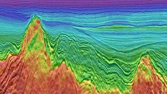
Benefit from exceptional imaging in Ireland’s Porcupine Basin to evaluate targets in Triassic/Jurassic fault blocks, through the Cretaceous section, and to the Cenozoic reservoirs. Viridien advanced pre-stack depth imaging includes full-waveform inversion (FWI) velocity modeling for unprecedented detail. High resolution in the shallow data provides clear, highly detailed images of channels and other features, also highlighted by the FWI velocity model.

Highlights
- 10,500 square kilometers of 3D and ∼2,000 kilometers of 2D long-offset broadband data, which provides enhanced low frequencies for unprecedented deep imaging
- Advanced broadband processing technology including GWE
- Final PSDM products for 2D and 3D surveys with FWI velocity modeling
- Depth control provided via 3D line well tie to 62/7-1

Request a Shapefile
Learn more about our multi-client library coverage. Request a zipped shapefile (.shp) for your region of interest.
Related Surveys
33rd UK Licensing Round
Jump-start your North Sea development plans with the most recent and advanced seismic data.
Greater Castberg
Get superior imaging with our state-of-the-art TopSeis™ data for shallow-to-intermediate-depth targets in the Barents Sea.
Northern Viking Graben
Mitigate near-field exploration and development risk in the Northern North Sea with new dual-azimuth data.
Explore available multi-client data using our interactive map.
Explore the GeoStore


